6 kilometers of canal, 110 meters wide, built as stormwater spine and public waterfront.
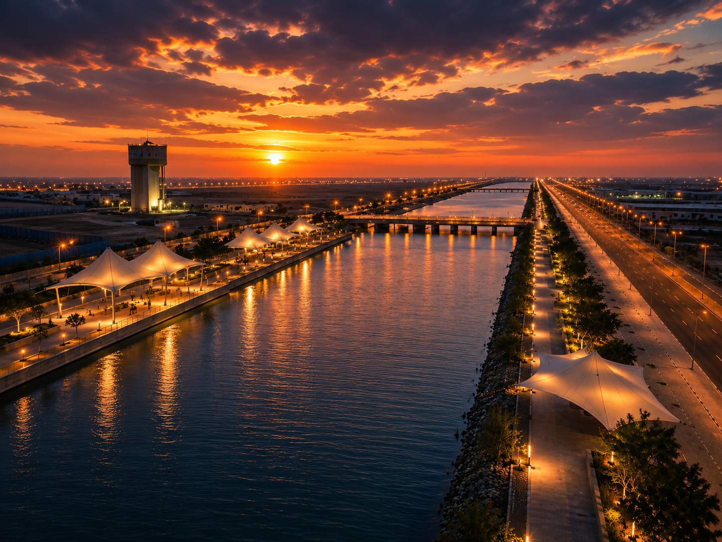
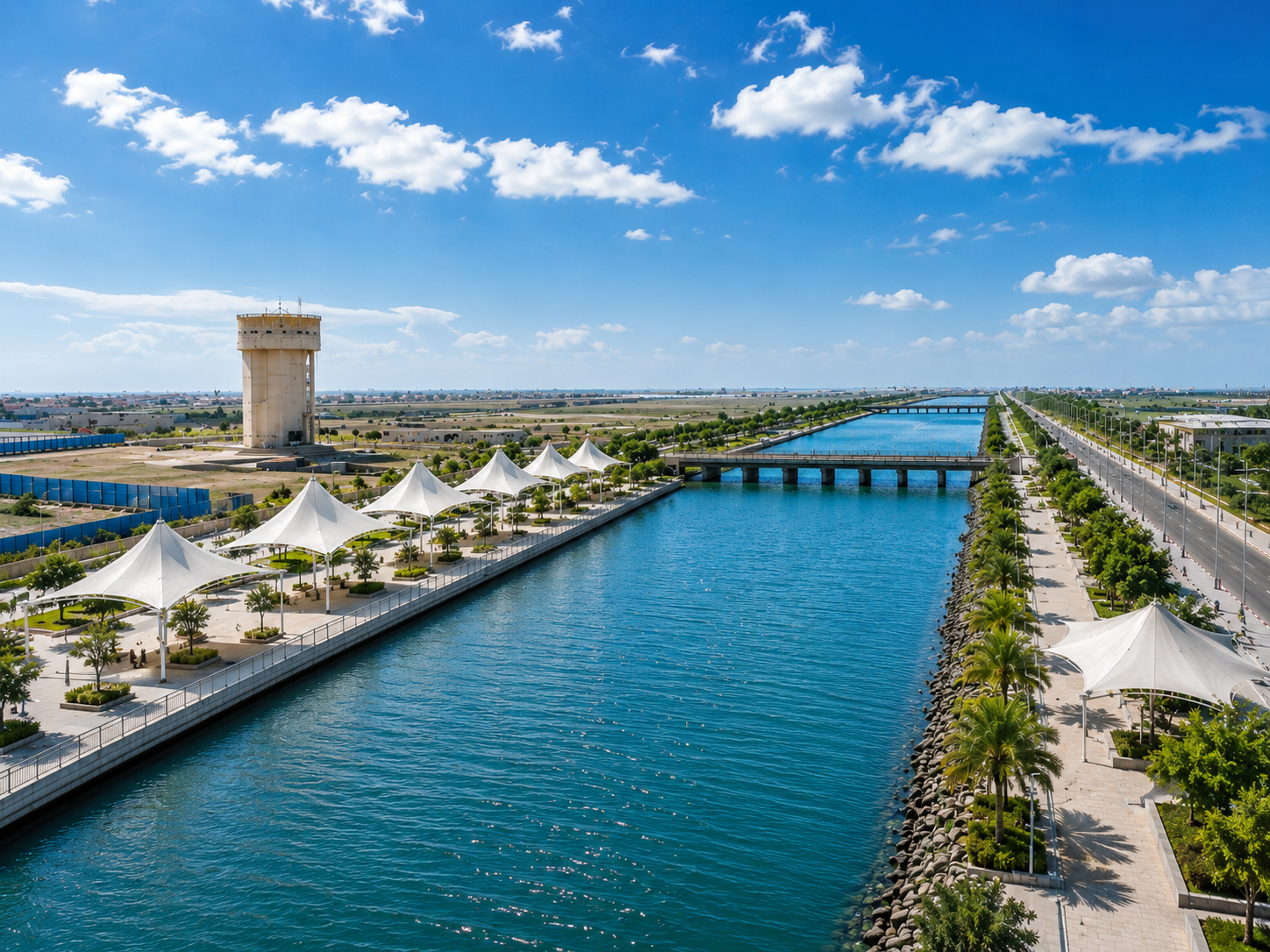
The photographs show a section of Dholera SIR's artificial river — a man-made canal that runs through the center of the Activation Area. On the left bank, white tensile fabric canopies shade a landscaped promenade with walking paths, gardens, and seating areas. On the right bank, a wide road runs parallel to the canal, lined with palm trees and additional shade structures. A bridge crosses the water in the middle distance. An elevated water tank — one of the 500-meter-spaced elevated storage tanks — stands visible on the left side of the frame.
This is not a decorative water feature. It is a functional stormwater drainage spine that also serves as the city's primary public waterfront space. The canal is 6 kilometers long in its current completed phase, 110 meters wide, and approximately 15 meters deep. It is part of a larger planned 15-kilometer artificial river that will eventually form the central infrastructure corridor of the Activation Area.
Dholera sits in a low-lying coastal plain near the Gulf of Khambhat. The terrain is flat, the water table is high, and during monsoon season, the region receives concentrated rainfall that has nowhere to go. In a traditional Indian city, this water would flood streets, damage buildings, and create waterlogging that takes days to drain. The groundwater would rise, basements would fill, and the municipal drainage system — usually undersized and clogged — would overflow.
Dholera's approach is different. Instead of relying on underground drains alone, the city built a massive open canal as the primary stormwater collection and conveyance system. The canal acts as a giant storm drain. During monsoon, rainwater from the 137-kilometer underground drainage network flows into the canal. The canal carries this water to nearby creeks and ultimately to the Gulf of Khambhat, preventing waterlogging throughout the Activation Area.
The canal also serves as a rainwater harvesting corridor. Water from the road network and building plots is directed into the canal through underground stormwater ducts. During dry periods, stored water in the canal can be treated at the Water Treatment Plant and reused for non-potable purposes, reducing dependence on the Narmada Canal supply. The system captures, stores, treats, and distributes — rather than just draining water away.
The artificial river is not a natural waterway that was dammed or redirected. It was excavated from scratch — 6 kilometers of open channel cut through flat, saline terrain. The channel is 110 meters wide at the top, narrowing slightly at the base, with a depth of approximately 15 meters. The banks are lined with rock riprap — large, irregularly shaped stones that prevent erosion from water flow and wave action.
The canal runs through the central corridor of the Activation Area, aligned with the main arterial roads. Beneath the roads and alongside the canal, the plug-and-play utility corridors carry potable water lines, recycled water lines, sewage lines, stormwater ducts, power cables, gas pipelines, and ICT fiber optic cables. The canal is not just a drainage feature — it is the infrastructure spine of the entire city. All utilities are co-located with the canal corridor, making maintenance and upgrades accessible without major excavation.
Underground stormwater drains from every plot and every road in the Activation Area connect to the canal through a network of collector drains and trunk mains. The system is designed to handle peak monsoon flows without overtopping the canal banks. During heavy rainfall, water levels in the canal rise, but the 15-meter depth provides sufficient freeboard to contain even extreme events. The canal then discharges to the Gulf of Khambhat through controlled outlets, preventing backflow during tidal surges.
The artificial river is not just infrastructure. It is public space. A section of the canal has been developed as a waterfront promenade with landscaped gardens, shaded walkways, jogging and cycling tracks, and leisure areas. The white tensile fabric structures visible in the photographs provide shade over seating areas and walking paths along the water's edge.
Over 1 kilometer of the canal has been beautified for recreational use, with additional sections planned as the Activation Area develops. The promenade runs along both banks of the canal, with the road on one side and the walking paths on the other. Palm trees, decorative lighting, and garden beds line the water's edge. The canal front is designed as a continuous linear public space — a place where residents and workers can walk, jog, cycle, or simply sit by the water.
The long-term vision includes a 72-kilometer waterfront development belt that will eventually surround the city with parks, promenades, cafes, and amphitheatres. This is not built yet — it represents the future urban design vision for the full 920-square-kilometer SIR. But the initial 1-kilometer stretch demonstrates the concept: infrastructure that serves a functional purpose while also creating livable public space.
The artificial river is one component of Dholera's integrated water management system. The system works as follows:
During monsoon: Rainwater from roads, plots, and building surfaces flows through underground stormwater drains into the canal. The canal collects this water, stores it temporarily, and discharges excess flow to the Gulf of Khambhat through controlled outlets. The 137-kilometer underground drainage network ensures that no area of the Activation Area floods during normal monsoon events.
During dry periods: Stored water in the canal can be diverted to the Water Treatment Plant for treatment and reuse. This harvested rainwater supplements the Narmada Canal supply, reducing the city's dependence on external water sources. The Zero Liquid Discharge system means that no wastewater enters the canal — only stormwater and harvested rainwater.
Year-round: The canal maintains a water level that supports the waterfront promenade aesthetic. Even during dry periods, stored water keeps the canal visible and the promenade attractive. The water quality is maintained through the stormwater-only design — since no sewage or industrial effluent enters the canal, the water remains clean enough for the public space environment.
The artificial river demonstrates something important about Dholera: infrastructure that serves multiple purposes. The canal is not just a storm drain. It is also a rainwater harvesting system, a public waterfront space, an infrastructure corridor for utilities, and an urban design axis that organizes the city's layout. This multi-purpose approach is characteristic of well-planned greenfield development — every element does more than one job.
For industrial investors, the canal means flood protection. Your facility will not be damaged by monsoon waterlogging because the 137-kilometer drainage network and the 6-kilometer canal handle the water before it reaches your plot. For residential investors, the canal means a waterfront address — a public space with walking paths, gardens, and water views within walking distance of homes. For commercial investors, the canal means foot traffic, aesthetic appeal, and a premium location for cafes, restaurants, and retail that benefit from the promenade environment.
The canal also signals execution capability. Dholera did not just plan an artificial river. It built one. The 6 kilometers are completed and operational. Water flows. The promenade is landscaped and usable. The infrastructure works. That execution track record matters for investors evaluating whether the rest of the city's plans will also be delivered.
See how the canal connects to the broader flood management system.
Read about Flood Management →Learn how the underground utility corridors feed into the canal infrastructure spine.
Explore Plug-and-Play Infrastructure →